operators stay high and dry thanks to remote controlled operation.
for environmentally sensitive areas like wetlands and dams.
to all the locations other survey vessels can't get to without a boat ramp!
zero emissions & a lightweight hull in the size of a computer desk.
in high risk environments
on ecological and asset sensitive environments
caused by incomplete survey data
yep, we don't even need a boat ramp.

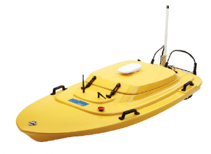
It’s a unique piece of tech that gets us anywhere. We’d know – completing over 100 jobs with it in 4 years! There’s no worries about safety thanks to remote controlled operation. It’s also zero emissions being battery powered. On-board is an echo-sounder for measuring depth & GPS with access to CORSnet, giving us high quality positional accuracy. In addition, we QA the data with local fixed benchmarks for high quality survey data, no matter the application or project.
We invest in up-to-date tech so you don’t have to.
If you cannot see or measure underwater, you’ll need us. We take the risk and hassle out of surveying that can really only be done effectively with our z-boat. Shallow waters, low clearance areas, ecological or asset sensitive water bodies, we have them all covered.
A battery powered, remote-controlled lightweight vessel. As big as a computer desk, it makes tight and hazardous areas accessible for surveying without the safety risks. It’s a breeze to use because it doesn’t require a boat ramp to launch from and we can pop it on the roof racks of our 4wd. We really can go ANYWHERE with this little boat.
Yep. We do that too. We have traditional surveying services to collect accurate MGA points which can be combined with the speed and detail of our reality capture services using our terrestrial laser scanner or Lidar Aerial Drone.
You’re talking to the right people. Our Z-boat is a zero fuel emissions, battery-powered and remote controlled vessel the size of a computer desk. It’s able to get to places a manned boat cannot, with minimal disturbance to flora & fauna, sediment and sensitive aquatic plants.
No worries! That’s why we look after being elite at it. Call us for a chat by clicking the ‘contact us now’ button at the bottom of the page.